- +1.604.730.8117
- +1.888.379.7601 (TollFree)
- info@Aquacoustic.com
- 188 West 6th Avenue, Vancouver, BC V5Y 1K6
Dam & Reservoir Survey Deliverables
Cliff Face Survey, Lake Powell
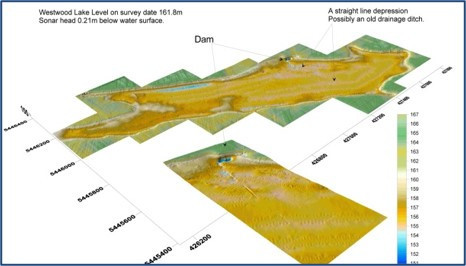
The above image, shows a surface map of a dam area with sonar below water & laser data above
CAD ready X, Y, Z data
The sonar profiles, motion reference data and payout figures are recorded to our proprietary software. The software is also used for quality control and post processing, and outputs X, Y, Z files suitable for computer rendering.
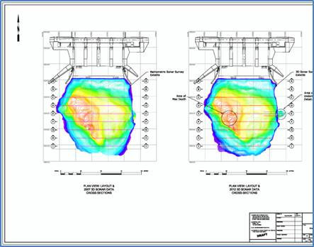
3D Sonar Rock Trap Survey
AquaCoustic can match deliverables to your needs.
Each survey is documented in a report that is provided in digital form as well as a pdf and includes drawings, DXF files, tables and any photographs or video.
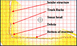
Sonar Profile from a Trash Rack Survey
In some instances a specific sonar profile indicates additional information that may be helpful, or shows unexpected anomalies or features. For this reason selected profiles may be included in the report.
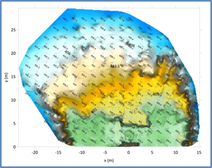
Sonar X,Y,Z data illustrates areas such as:
- Volume of build-up on trash racks.
- Bottom trends.
- Volume of siltation.
- Comparisons with as-built drawings.
- Areas of scour.
- Size and shape of plunge pools.
- Size and shape of sink holes.
- Overlay repeat surveys for historical comparisons.
- Water volume for inundation studies.
Spillway Scour Hole Survey
The survey was to accurately portray the shape of the scour hole, including any undercutting. Compare to previous surveys
This work included:
- 3D Sonar profiling of the scour hole.
- Profile the spillway channel down stream of the spillway structure.
- Produce X, Y, and Z data, referenced to existing dam coordinates.
- Produce an AutoCAD drawing of the area.
- Produce and compare volumes and mesh overlays with the previous surveys.
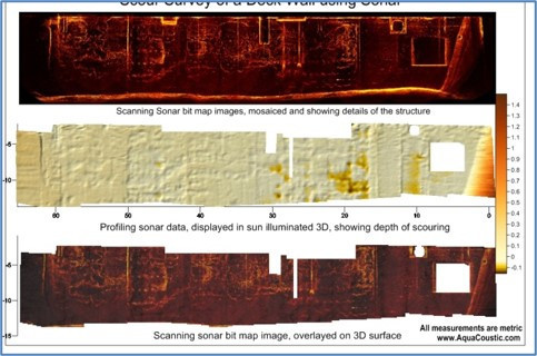
Measure concrete spalling
A profiling sonar was used with an accuracy of ½ inch (12 mm) Local coordinates were used for positioning
The purpose of the survey was to:
- Collect sonar data on the concrete face.
- Produce detailed 3D data of the area.
- Tie the survey in to known positions and elevations.
- Supply X,Y and Z data.
- Produce accurate drawings.
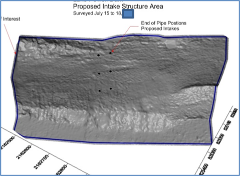
Cliff Face Survey for Planned Intake Structures
The survey area was approximately 300 meters (1,000 ft.) long by 126 meters (413 feet) deep.
The work included:
- Sonar profiling the cliff face.
- Include the debris at the toe of the cliff.
- Produce X, Y, and Z data, referenced to existing dam coordinates.
- Tie in the existing aerial survey.
- Tie in to existing control points.
- Create a data set of the area of interest.
Download our PDF for more information and up-to date deliverables