Aquacoustic

Shafts & Boreholes Technology

Collect bottom data under floating obstructions

Through drilling mud

We have developed a system that can profile through drilling mud

Survey down 1,000’ (300 m) depth or more, Up to 60’ diameter or larger.

The system can be shipped by air cargo.

Minimum borehole dia. 6 inch

An in house designed system that can be deployed through 6” boreholes
Depths of 1,000’ attainable

170 ft. range

Better than 10 mm accuracy.

Ruggedized system

We used an available length of pipe to build this protective electronics body. The unit carried our marine camera, sonar head, lights & client specified sensors

Deliverables include processed images as well as XYZ point clouds

CAD ready data

Flooded mine stope surveyed through five boreholes 6 inch diameter

Our survey was used to calculate the available volume and to correct old drawings

Rock drilled borehole, above water

Software & Hardware.

Quick solutions for emergency work.

30 yrs of experience in problem solving.

Selected Sonar Cross-Section

Sonar cross-section image of an old hand excavated vertical shaft. The survey was to ascertain whether the water pipe had been impacted over time. The image shows the water pipe to the left of the sonar head. (circle with the cross)

Meshed sonar XYZ data

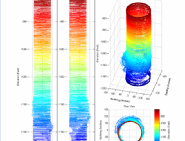
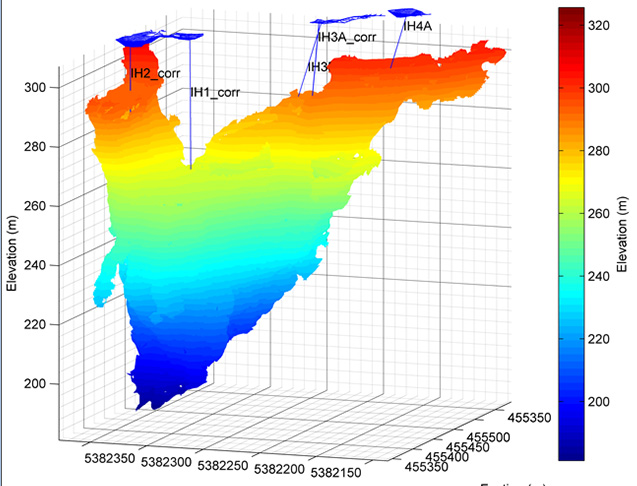
Used for volume calculations, co-ordinates and condition. We can merge multiple surveys together to form one drawing. We have 2,500’ tether lengths available.

Useful sonar range of 50 m
Sound footprint, approx.3% of range Tie into local co-ordinate systems.

3D laser for above water surveys.

Below water survey of a rock drilled borehole.

Profiling sonar was used for the below water survey. The sonar data showed the extents of the cracks. A marine camera was also incorporated in the survey.
 

Useful sonar range of 50m

Minimum sonar range 2 inches

Sound footprint, approx. 3% of range.

Tie into local co-ordinate systems.